Difference between revisions of "Geopsy: Set receivers"
| Line 1: | Line 1: | ||
| + | [[Image:StationCoord.png|thumb|400px|Set receiver window]] | ||
| + | |||
Set receivers option allows to edit receivers position in a relative or absolute positioning system. | Set receivers option allows to edit receivers position in a relative or absolute positioning system. | ||
| − | When the set receiver button is pushed in the [[Geopsy: Edit menu|Edit menu]] a window appears in which station positions are displayed as a table. | + | When the set receiver button is pushed in the [[Geopsy: Edit menu|Edit menu]] a window appears in which station positions are displayed as a table. |
Default fields displayed in this table are: Station name, X, Y & Z coordinates. | Default fields displayed in this table are: Station name, X, Y & Z coordinates. | ||
Receiver positions can be edited in different ways. | Receiver positions can be edited in different ways. | ||
*A first option is to edit the relative position of each selected station directly by typing it in the X, Y & Z fields. | *A first option is to edit the relative position of each selected station directly by typing it in the X, Y & Z fields. | ||
| − | It is also possible to add station in current selection pressing | + | It is also possible to add station in current selection pressing [[Image:AddStationButton.png|middle]]. |
| − | *A second option is to press | + | *A second option is to press [[Image:LoadButton.png|middle]] in order to load a coordinate file in ASCII format or a [[SciFigs: Multi-column Parser|parser]]. When the load button is pressed it is possible to browse to the directory of the selected coordinate file and open it. As the open button is pressed a new window appears by which importing options can be specified, like for instance coordinate units or file columns/rows to be read (refer to the [[SciFigs: Multi-column Parser|parser]] page for further details). |
| − | Coordinate files can be also saved pressing | + | Coordinate files can be also saved pressing [[Image:SaveButton.png|middle]].[[Image:LoadCoord.png|thumb|right|400px|Load coordinates window]] |
| − | + | ||
| + | |||
An example of simple coordinate ASCII file is provided hereafter. | An example of simple coordinate ASCII file is provided hereafter. | ||
| Line 20: | Line 23: | ||
WA_WAU07 2056 2056 0 | WA_WAU07 2056 2056 0 | ||
| − | Furthermore starting from the Set receiver window it is possible to display the absolute distance in meters and the azimuth in degrees calculated between any receiver pair. In order to calculate distances beetween receiver pairs, push | + | <br style="clear: both"/> |
| − | + | [[Image:RelPos.png|thumb|right|400px|Relative position window]] | |
| + | Furthermore starting from the Set receiver window it is possible to display the absolute distance in meters and the azimuth in degrees calculated between any receiver pair. In order to calculate distances beetween receiver pairs, push [[Image:RelPosButton.png|middle]] in the Set receivers window; in this way a new window appears. In this window you can press [[Image:AddButton.png|middle]] in order to display distance and azimuth between receiver pair. You can select any receiver pair clicking in the cells that contain the receiver names. Furthermor it is possible to add (and remove) new receiver pairs as rows in the same window and display the average distance and azimuth. | ||
Latest revision as of 15:43, 12 March 2010
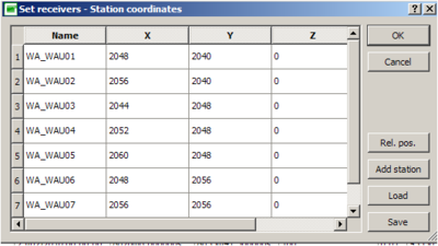
Set receivers option allows to edit receivers position in a relative or absolute positioning system. When the set receiver button is pushed in the Edit menu a window appears in which station positions are displayed as a table. Default fields displayed in this table are: Station name, X, Y & Z coordinates. Receiver positions can be edited in different ways.
- A first option is to edit the relative position of each selected station directly by typing it in the X, Y & Z fields.
It is also possible to add station in current selection pressing ![]() .
.
- A second option is to press
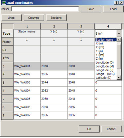
 in order to load a coordinate file in ASCII format or a parser. When the load button is pressed it is possible to browse to the directory of the selected coordinate file and open it. As the open button is pressed a new window appears by which importing options can be specified, like for instance coordinate units or file columns/rows to be read (refer to the parser page for further details).
Coordinate files can be also saved pressing ![]() .
.
An example of simple coordinate ASCII file is provided hereafter.
# Station_name        X      Y       Z
# (station_name cannot contain blanks)
WA_WAU01 2048 2040 0
WA_WAU02 2056 2040 0
WA_WAU03 2044 2048 0
WA_WAU04 2052 2048 0
WA_WAU05 2060 2048 0
WA_WAU06 2048 2056 0
WA_WAU07 2056 2056 0
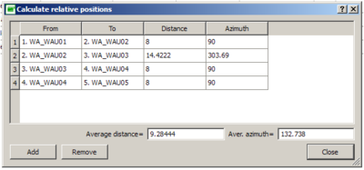
Furthermore starting from the Set receiver window it is possible to display the absolute distance in meters and the azimuth in degrees calculated between any receiver pair. In order to calculate distances beetween receiver pairs, push ![]() in the Set receivers window; in this way a new window appears. In this window you can press
in the Set receivers window; in this way a new window appears. In this window you can press ![]() in order to display distance and azimuth between receiver pair. You can select any receiver pair clicking in the cells that contain the receiver names. Furthermor it is possible to add (and remove) new receiver pairs as rows in the same window and display the average distance and azimuth.
in order to display distance and azimuth between receiver pair. You can select any receiver pair clicking in the cells that contain the receiver names. Furthermor it is possible to add (and remove) new receiver pairs as rows in the same window and display the average distance and azimuth.


